Kinder
Locally you would say you 'are going up kinder' but in reality you would be following the river Sett up to the point the river Kinder joins it at the 'Roman Bridge' there are two routes either up Kinder Rd which lies on the north of the river or Valley Rd to the south.
We shall take the Valley Rd routeFrom the Parish Church turn up Church street with the Bulls Head Inn on your right. At the top take the left fork and follow the road keeping the river on you left this is the most strenuous part of the walk
As you walk up the road keep an eye on the opposite bank of the river to see if you can make out the route of the old railway line which was used to take construction materials and labour up to the site of the Dam that was under construction 1900-1911
When you go through a passage with large stone pillars at the start of the Camp site you are at the point where the railway line crosses over on to your side of the river and the road at the side of the camp site is on the track bed.
It continued on up the road and crossed the river sett at a point just to the right of the 'Roman Bridge' the bridge is long gone but the abutments are still visible
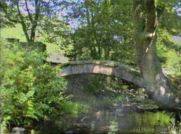
An old Pack Horse Bridge known locally as the 'Roman Bridge' spans the Kinder brook at a point just before it joins the river Sett
This is the site of the first recorded 'Church' in the parish, predating the 1386 Church down in Hayfield Village. The area was known as Kirksteads, now it is known generally as Bowden Bridge, a more substantial road bridge was built crossing the Sett to give vehicular access to the long gone Kinder Print works (now the Puddle fields) some 50 yds down stream
'Roman Bridge'
(c) hayfield.info Please respect the generosity and rights of the people who have contributed to this site all rights reserved, no material is to be copied or used for any purposes without first obtaining their permission via info@hayfield.info