Little Hayfield
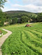
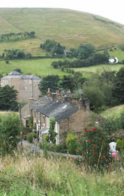
From the centre of the Village with the Church and Bull at your back cross the bridge and walk down Market Street at the end of the row of shops, turn left down Mill Street which takes you down to the bank of the River Sett, follow it under the road bridge the path then takes you through the 'Old' School field on your right you can see the stage where in May the crowning of the Village May Queen takes place, on your left across the river is the site of the Wood Print Works and two lodges (large mill ponds) now a prestige housing development. In the distance you can see Lantern Pike.
You emerge from the field on to Swallow House Lane in front of what was a branch of the Co-operative Society now a private house, turn left down the lane.
On your left is the Wood Gardens estate formally the allotments and gardens for the Wood House the residence of the wood print works manager.
Continue down the lane until it forks take the left fork down Bank Vale whose 'dry stone' walls are coated with moss and lichen. On the right is the village Football field and to the left is the Oaklands now prestige flats formally the home of the owners of 'Slacks Paper Mill' the 'coach house' has some interesting details including a dove loft
The road dips and at the bottom you will see a group of farm buildings on the left is Bank Vale Farm now a private residence to the right is a stile which leads across the middle fields, (there was a Wrought Iron swinging gate style but this has been engulfed by the tree you can still see some of the bars emerging from the bark)
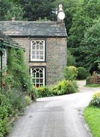
If you require a relatively flat route take this path. If you can cope with stairs then straight on brings you to Bank Vale House with its distinctive window frames. The road turns left between the house and Bank Vale Farm into the farm yard and then over a bridge into the Slacks Paper Mill yard, but carry straight on.
Keeping Bank Vale House on your left you cross a stone footbridge over the river. You will notice a culvert running around the bank this took water from further up the valley to the Paper Mill.
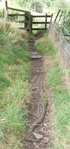
This section of path is known as the 'Giggle Gaggle' and becomes rather steep and difficult, as erosion has exposed tree roots and bed rock, continue up with care and you come to a gate style
Decision point - left takes you along to the Bank Houses on Thornset lane and back down into the village or up to Windy Knoll
Turn right this takes you up the valley to Little Hayfield, you can see the river on your right at the bottom of a steep drop, you pass through a style and are faced with a fork in the road.
Decision point - Left takes you higher up the hill Right takes you down into the Hamlet of Little Hayfield..
Take the right fork, you pass a row of stone cottages on your left and cross the river in the valley bottom over the new bridge built in 1945
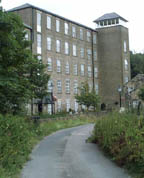
This area is known as 'Buckram' and on the right is the site of Buckram Mill of which no trace exists, follow the road and facing you is Clough Mill the only remaining Mill in the Parish which is now luxury flats. (on the left you will notice a footpath crossing the river just before you get to the mill remember this for later) if you follow the road as it winds up the right side of the valley you come to an open area where the path across the middle fields joins the road. You can take this path back down into the village emerging on Bank Vale Road or
If you feel a little more adventurous after exploring Little Hayfield walk back down to the foot path I mentioned earlier near Clough Mill.
Here the river running down from Park Hall Moor through the hamlet joins one from Car Meadow you will see footbridges crossing the rivers follow the path over and you will start to climb up the bank, the route is marked with a series of flag or stepping stones up the field. You are heading for the house above the white house. You will join a track just before it continues on up above Hey Wood.
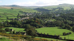
Here take a left and follow the track back towards Hayfield you will pass Cliffbank Farm note the corner stone work and vestiges of shutters on the hayloft windows, continue on and just before you join the track down to Buckram there is a path on your right marked by a green, grit bin if water is not flowing down the path and you have the time follow this route it takes you up a little higher in a gradual climb above the Bank Houses. Not forgetting to take in the views over Little Hayfield to Kinder, Eventually you will come to what appears to be a walled track, down to your left you will see the road but first pause a while and in the distance you will see on the horizon the 'Lyme Cage' at Lyme Park Disley. Then take the path down to the road When you join the road take a left down towards the Bank Houses you can either follow the foot path in front of the houses which will bring you out at the top of the Giggle Gaggle, or continue down the road noting the height of the wall and the fact that in living memory this used to be filled with snow, In the wall on the left behind a on ended slab you will find the well supplying water before piped supply Following the road down will bring you to Slacks Bottom you will see what is left of the Paper mill on your left
A little further up the road on your Right is the Village School and 'Swallow House' which gave its name to the Lane. continue on under the A624 and join Market street at Toll Bar corner the Tollbar Inn to which the two houses on your left were attached was demolished for road widening. The large building on your right was the Village school is now Primrose Court housing for our Senior Citizens. Turn right and walk down the Wain House back into the centre of the village
(c) hayfield.info Please respect the generosity and rights of the people who have contributed to this site which is for private and educational use only all rights reserved, no material is to be copied or used for any purposes without first obtaining their permission via info@hayfield.info